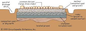
Could a Roman road have passed through Weaverham from Sandiway heading towards Warrington? Mr Kirk (footnote 1) in the 1880s certainly thought so. He maintained that in 1876 the remains of a road were found under Weaverham’s church chancel.
The road would have run from the area of Cuddington Station, over the fields crossing Handford Brook and on to Lakehouse Field in the centre of the village, through St Mary’s Parish Church and then the Weaver Valley, via Saltersford to the Daleford Gap and so on to the thriving Roman town of Warrington.
What remains of the Roman road? There is now nothing to be seen. Looking at the roads in the area it is believed that the A49 follows the route of the old forest Peytefinsty road. This would have followed a marshy route but the Romans tended to build on high, dry ground so maybe their road would have been to one side of this current busy A road.
The History Society has dug a number of test pits in the past but the area is heavily farmed and marled. At Handford Brook Farm an area of undated cobblestones were found which was on the line of the pre-railway road at Gorstage. Also in the 1980s blocks of sandstone were found in Millington Lane, Gorstage which could have been the base of a road and the Weaver valley has yielded Roman coins, brooches and figurines.
So currently there is no definitive confirmation that we have a Roman road passing through or near to our village – but perhaps there is a solution using technology rather than spades.
By using light detection and ranging (Lidar) technology the Environment Agency can detect the areas of Britain which are most at risk of flooding. This precision technology can detect differences in the height of the land of as little as 5cm, making it ideal for detecting hidden structures buried under the soil. Although the
Environment Agency has been using the technology for some 20 years it has only made freely available to the public since 2013. From that time amateur archaeologists have been able to use the flood maps produced by the Environment Agency to discover 7 new Roman roads in the UK, the most recent being one that connects Ribchester and Lancaster.
The Lidar technology helps archaeologists trace the Roman roads because they were originally raised about 50cm above the ground. Although these roads have now been eroded by hundreds of years of weather and farming work, sections of the roads remain raised. As the Lidar technology is able to detect the raised ground with such precision, it is more effective than the human eye for tracing the route of the road, particularly across large distances. By plotting the raised sections on a map amateur archaeologists are often able to trace the original route of a Roman road.
So, maybe before too long it may be possible to know whether there really was a Roman road in Weaverham.
1 Edward Kirk (1832-1886).
“Roman Roads in Delamere Forest and neighbourhood.”
Lancashire and Cheshire Antiquarian Society, Vol III, 1885.
(Diagram courtesy of Encyclopaedia Britannica, Inc. / Google Images)

