
The original name for the township was ‘Weaverham cum Milton’; the Parish (a parish being composed of several townships) was ‘Weaverham’.
The parishes were set up by Theodore, Archbishop of Canterbury in the 7th century. In the Domesday Book there are only a small number of parishes with a priest and Weaverham was one of them.
One name for Weaverham is ‘Weaverham Alba’ (meaning ‘white’). One theory is that this is because the Mediaeval White nuns of Chester owned Weaverham Wood.
The Saxons divided the country into ‘hundreds’ and Weaverham is part of the Eddisbury Hundred.
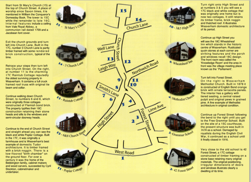
Blue Plaque Scheme: In 2009 the Weaverham History Society, The Weaverham Trust and Vale Royal Borough Council were responsible, with consent from the owners, for the positioning of 15 [including the parish church] blue plaques on listed properties in the village. These are show in italics in the following ‘tour’ of the village. The historic walk through the village is about 1.3 miles long and can be completed in about 40 minutes. Although this walk includes other buildings of interest, it follows the same route as the sketch map given on the Blue Plaque Walk leaflet available from The Weaverham Trust, Weaverham History Society and Weaverham library.
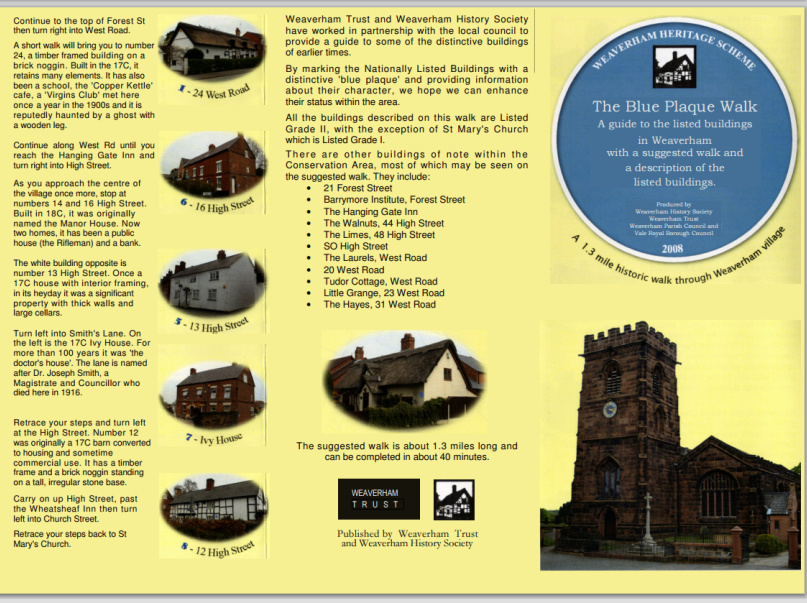
Download the leaflet as a pdf BluePlaqueWalk
The Parish Church of St Mary the Virgin. – Grade 1 listed building. The church is open from 10.00 am until 3.00 pm every Saturday for those who wish to look around. Although this has been a place of Christian worship since Saxon times and the church is mentioned in the Domesday Book, the present church building is more recent.
The tower was built in the 15th century and the remainder of the present building (apart from the small 20th century toilet extension – south door) was constructed in the 16th century. The building is constructed of local ashlar sandstone. There are several interesting internal features, including a ceiling from Vale Royal Abbey, a communion rail dating from 1709, and a Jacobean font cover. Written guides are available inside the church. Parish registers date back to 1576. The church has 6 bells: two from 1718, two from 1796 and two from 1875. The churchyard was plundered by Parliamentarians during the Civil War. Old men were tied to carts and dragged through the mire. Cavaliers billeted in the school, defaced the school house, causing the school to be held in the church which they also damaged. About 50 human skeletons were found during excavations in the churchyard in the 1930’s. Each one had a large hole in the forehead. It is thought that these bodies are evidence of a mass execution here during the Civil War
As you leave the Church on the left hand side was the original ‘Ring of Bells’ pub. There were also some 200 year old cottages. The pub and cottages were knocked down in the 1960’s. The name ‘Ring of Bells’ is normal for a pub near a church. In the past the pub had also been called ‘The Church Stile’ and ‘The Gatehouse’ which may indicate that there was once a lych-gate at the entrance to the churchyard and at one time a stile. Some people think it was called ‘The Church Stile’ because you had to get past it to get to the church. (As we all know, a lych-gate is a roofed gateway to a churchyard under which the corpse is set down at a funeral, to await the clergyman’s arrival).
Vicarage Area: This is the highest point in village. There was an early British camp of the Cornovii Tribe here. They worshiped the horned god Ceruunos.
The old vicarage (which was knocked down and replaced by the present one in the 1960’s) faced down into the village. It was a double fronted brick building, with sandstone facing around the windows.
Pinfold and pinfold gate: Stray sheep, cattle (or other animals) found wandering in the village were kept here until claimed. The stocks were also here.
Site of Church House: was a ducking pond where gossips etc were ducked – hence, the name of the field on which Church House was built – ‘Cuck stool’. All the surrounding land was Glebe Land (ie land belonging to the church).
3 Church Lane – originally two 17th century thatched cottages – Grade 2 listed. Partly timber framed with some rendered brick. Internal timber framing is exposed.
Scout hall: There are two scout groups in Weaverham – this one being Sea Scouts and the other being Baden Powell Scouts in Owley Wood.
Well Lane: There was a beautiful well down there and it was said that if you drank the water you would come back to the village. It was an open spring which never ran dry and well into the 20th century was the only source of water for some houses. It was also credited with healing powers. It now runs through pipes under the back garden of a bungalow.
En route there are two rather interesting little roads: Moss Street and Woodward Street. Note the yards behind the houses – in the Middle Ages craftsman would have worked in the yards behind their houses, though these cottages are from a later period.
Just before Rain Tub Cottage there used to be a row of terraced cottages and a general store called Allman’s. These were all pulled down in the 60’s.
11 Church Street – Raintub Cottage – Grade 2 listed: other than the church this is possibly the oldest building in the village and was originally 3 cottages. A cruck building with gable end opening on to the street. Part of the cruck was still visible until the last reconstruction. It contained an unusual frieze of red flowers and green leaves, which were supposed to protect the house from evil. (Normally yew was believed to keep off evil spirits, but this looked more like tulips). It was on the plastered wall and the owners at the time of reconstruction had it covered up, but said they were going to have it copied on to the fireplace. A coffin hole in the ceiling allowed the coffin to be lowered, as the stairs were too narrow.
Number 3 Church Street, once called Holly Hurst. (Until 2010 the post office). Quite old. Some very old timbers inside. There is wattle and daub at the back. This is where the oil was stored for lighting the street lamps. There were 24 street lamps in the village. One was by Rain Tub Cottage and another opposite 12 High Street.
6 and 8 Church Street – Grade 2 listed: (opposite former post office). 18th century – have date (1772) on them. Constructed of Flemish bond brick with a slate roof. Note the typical channelled stone heads and sills to the windows and semi-circular heads to the doorways.
Car park: Some small ‘two up – two down’ houses on the High Street which backed onto the car park, were demolished in the 60’s for road widening.
Garage: this area used to be Lakehouse Farm – so named because it had 3 pits, which were probably at the bottom of Lakehouse Field (now our village green). ‘Lacu’ is the old name for a watercourse.
High Street:
Poplar Cottage – Grade 2 listed: a timber framed thatched cottage with brick nogging on a stone base. Said to be our best example of domestic 17th century architecture. Note the eyebrow windows. Originally a two roomed farmhouse with a baffle entry. Note the large wheel set into the wall on the left hand side of the building – possibly signifying that it was once a wheelwright’s. From the end of the 19th century it was the home of the Bebbingtons, cabinetmakers and woodcarvers. Charles Bebbington, Parish Clerk and Sexton, is commemorated by a fine plaque in the Parish Church. LHS of the cottage was one storey and was the old workshop. After he died the business was taken over by his former apprentice, Cyril Stockton – cabinetmaker and undertaker. There was a birth chamber on the ground floor (left hand side of the present two storey building). This was slightly lower than the rest of the ground floor (which was an earth floor) so that you had to ‘take one step up’ after your birth. This was so that you would attain some ‘height in your life’ and ‘do well for yourself’. Hence the expression ‘going up in the world’.
Like many other old houses demolished in the 1960’s there were plans to knock down Poplar Cottage for road widening but there was so much protest that the plans were scrapped.
The old chemist’s shop – No. 1 High Street (between Poplar Cottage and Buttercup Cottage): Built in the 1850’s probably on the site of an older building. It was a pharmaceutical chemist, tea dealer, grocer and seed merchant in the 19th century (i.e. multipurpose) The pharmacist was John Manifold and the grocer was Isaac Nicholas. John Manifold was a church warden and it is said that it was ‘mainly through his efforts that the edifice was restored’. He died in 1904. According to his obituary ‘he was well known and very highly respected’. Isaac Nicholas died in 1913. The shop was sold in 1932 and records show that Edward Cyril Catley (born 1909) was running a chemist shop there in 1939 (he may have been there since 1932). He continued to be the local pharmacist until late in the 20th century when, as a very old man he sold it to a company (thought to be American) called Sunscrit who in turn sold it to the Cohen’s pharmacy chain. It was converted to a dwelling in 2007.
3 (Buttercup Cottage) and 5 High Street – Grade 2 listed: Originally one 17th century timber framed thatched home with brick nogging standing on a stone base. Later became a shop and cottage. Within living memory No 3 was once Mrs Burn’s General Store and Carpentry. Now two cottages (nos 3 & 5) they retain many original features both internally and externally.
Next door, where Toppers hairdressers is, there used to be a pub called ‘The Star’. The steps are still there (entrance to ‘Toppers/and a shop). Just outside there was a hook for the bear in the days of bear baiting. (The bear was kept in a house further down the High Street.) The locals called the area between The Star and The Wheatsheaf ‘Parliament’. It is said this was because the men would fall out of the two pubs and have arguments/discussions there. It was, in fact the village meeting place. The twin maypoles may have been here.
Forest Street: Old name of Forest Street was ‘Out Lane’ because it led out of the village. There was a thatched cottage and a farm before reaching The Barrymore Institute – both pulled down in the 60’s. Bebbinton’s land reached right up to the school and was an apple and pear orchard.
Barrymore Institute: Lord Barrymore gave this timber-framed building to the village one hundred years ago in 1907 as a recreation centre. There were two bowling greens at the rear and billiard tables inside. During and after the war it was used by Forest Street School as an additional classroom for evacuees. Later, it was used by a boxing club and is now used by a weightlifters club.
Weaverham Methodist Church – Grade 2 listed: From September 2009 the Methodist congregation has joined with St Mary’s Church of England to form a New Ecumenical Church (Joint Christian) worshipping at St Mary’s. it is now deconsecrated with plans to convert it to a nursery. Built in 1878. The Sunday school building on the left was built much later. The Church is constructed of English Bond orange brick with ornate terracotta decorative panels. Inside the church used to have a raised central pulpit, an organ, the original grained pine fittings and pews as well as a gallery with tiered seating. The organ has been installed in a church in Italy, the pews and pulpit were sold to a man in Bradford who specialises in selling old church furniture.
Forest Street School: LHS – (the part which was the school hall in the 1980’s) was built in the 1840’s. Smith Barry (who later became Lord Barrymore) gave this to the community. It was originally a Church of England school. The RHS was added in 1907. There have been many alterations and additions in the past 20 years. The site of the shed was until recently the site of a small building which was used by a group of women (possibly mothers) to cook food for the children – before the time when school dinners were provided by the County Council).
During the Second World War – on the corner of Forest Street (no 1 Fieldway – bungalow on raised ground) – was the site of the village air raid shelter. (This was before Fieldway was built and the land here was much higher).
The water tower was where the Fieldway sub-station is now.
No 34 Forest Street – the old police house – originally a police station which once had a sergeant and 3 policemen.
36 Forest Street – (Worthern) (The big house next to the grammar school): –was once the home of the headmaster, Mr Trickett.
38 Forest Street: The Free Grammar School – Grade 2 listed – the school was founded in 1638 and our sources* suggest that the stone building may be older. Some say that this (not Rain Tub Cottage) may be the oldest house in the village. The extension (No 40) was built in the 19th century. For 200 years prior to the Dissolution the abbots of Vale Royal ruled Weaverham. The school was built on the site of the Vale Royal Abbey courthouse. Offenders were taken across the road to Gibbet Hill (now High School playing field) or down the rear path to the prison. (This path can be followed into Brookside and continues between the houses from Fieldway to the High Street). The present house retains the stone mullioned windows of the period. The school closed in 1916. NB The building was damaged by royalists during the English Civil War.
*eg the book ’Cheshire Village Memories’
42 Forest Street: Timber framed thatched cottage next to the school – Grade 2 listed once a farmstead which sold milk
21 Forest Street – School Bank – (Small thatched cottage opposite Longmeadow): Originally one of 6 cottages. The other 5 burnt down when evacuees occupied them.
West Road – The old name for West Road was Peytefynstey Way. More recently it was known as ‘Back-o-Town’.
By-pass built 1992. Corner of West Road/by pass was Nook Farm which was blown up by land mine in 1940.
Many of the houses in West Road were built in the 19th century.
24 West Road: Thatched cottage Grade 2 listed – An example of a timber framed, three bay baffle entry house. (Baffle entry – can’t go straight into a room – a wall in front of you). Built on stone base with brick nogging. It has been much restored, but some of the old timber and daub remain. It was originally a farm worker’s house, and later a school. The cottage apparently boasts a ghost with a wooden leg. In the cottage was found a summons to the court in Weaverham dated 25 October 1754. It read: ‘John Crimes you are to serve on the jury at Weaverham Court tomorrow. Fail not. C Booth.’ – The courthouse at this time was in the High Street.
In the late 19th century The Virgin’s Club met here annually. They dressed in white and then marched to church for the service before going to the Star Inn for a meal. It is not known why it was called the Virgin’s Club. It might very well be because they attended the church which is correctly named ‘The Parish Church of St Mary the Virgin’.
The thatched cottage was ‘The Copper Kettle’ café in the 1930’s. Like many houses in the village in the 20th century it was once a private school.
No 19: In the early 1960’s this was Miss Sutton’s Private School (ages 5-11).
Opposite Tower Lane is a footpath continuation to Acton Bridge.
20 West Road: The house was formerly an Associated Methodist Chapel known as the Ranters Chapel. For many years a staunch group of Methodists established themselves in Weaverham holding services here and in other cottages in the village.
Tudor Cottage, West Road: (no 1 West Road – confusing for a new postman!). This cottage was originally three, one up and one down cottages, each with a lean-to kitchen but with only one cold-water tap between them. The privy was at the end of the garden and it was emptied by the soil cart. The house was remodelled using the original timbers.
Next door – Ivy House: once the home of the district nurse who cycled to her patients.
The garage is on the site of a shop called Forsters – demolished in the 60’s.
The Hanging Gate: An early 18th Century farm pub originally called Gate Inn (gate meaning highway). It was the last farm pub in the village. Formerly two small rooms, which became two bars. The pub was part of the Marbury Estate, which accounts for its other name, The Barrymore Arms. Indeed, Lord Barrymore’s agent used to collect his rents here. In 1932 it was sold to Greenall Whitley and became the Hanging Gate. The mounting block: may once have been a cheese weight, which was cut down to make a mounting block for pub clientele. The building is now a restaurant.
In the present pub garden, until it was demolished in the 60’s, there was a black and white cottage called ‘The Inglenook’. There was also a huge lime tree. There are still a few lime trees around here (eg garden of Elston), which were planted to celebrate the silver jubilee of King George V in 1935. There was also a huge lime tree in the centre of the junction (sawn down, because of disease, 11 or 12 years ago). It had seats around it where old men used to sit and chat. The present young tree was planted as a replacement, in memory of Princess Diana.
High Street:
Pear Tree House (no 68) was once a school and no 64 was once a vet’s.
New Room/Temperance House (no 54): the Burgess sisters who also lived there built this former meetinghouse.
Weaverham Bank Farm was owned by Mr Hall in 1658. If ‘Mr’ in records it means he was gentry. Some windows are blocked up due to the 18th century Window Tax (repealed in 1851).
No 39 (The Spinney) – next door to farm: until the 1960’s there was a black and white cottage here (but nearer the road). This is where a family lived and kept a bear for bear baiting (which took place outside the Star).
The Walnuts, 44/46 High Street: An early 19th century property owned by Benjamin Burgess from which he ran a saddlers, drapery, and furniture business, later selling agricultural implements. Later, this half of the business became well known as Burgess Bros. (Agricultural Engineers) Ltd. The original Burgess Bros. signs are still there (round logos either side of door). During the Second World War, it became an egg packing station. It used to have a mulberry tree in the garden.
Town Farm, 44, High Street: (between The Walnuts and the white cottage). A small holding central to the village, with cobbled yard and shippons/shippens (cowsheds). The gable end of the house has windows, bricked up due to the window tax. Before the war, a coal merchant, whose office was at the end of Chapel Street, kept the farm. The twin maypole probably stood close to the farm (although it may have been in ‘Parliament’) – Two maypoles topped with a sapling, so that they looked like trees.
The Indian Restaurant (no 22) and house next door: was once the Co-op. Note the old position of the hoist (no longer there).
The boarded up shop, no. 20A: at the back of this house is a Smith-Barry stained glass window.
Approaching no 23A there is a pathway* leading to Fieldway. This was once an old lane leading between the Court House and the prison. (This is a continuation of the lane between 40 and 42 Forest Street)
No 23 (now a hairdressers’ shop), 23A, and the ‘new houses’* (previously site of coal yard): There was a stone prison on this site until 1832 which was then rebuilt but demolished in 1875. In the middle of the 20th century two of the oldest villagers could remember being locked up in the prison as boys for some misdemeanour. An old door, believed to be from the prison, was inside no 23 when it was Hornby’s Store. (Some of the stones used in walls around the village may have come from the demolished prison.) Because of its proximity to the old lane (now a path* – see above) leading to the courthouse many people believe that the original prison of the Abbot was on this site. Many others believe it was situated at the end of Chapel Street. Could this have been the site of the courthouse after the one in Forest Street was demolished? We do not know.
No 19: Used to be the coal merchants’: There are now houses on this site.*
No 32 was once a shop, as were many other houses in the High Street in the 20th century.
Chapel’s ‘wine bar’: The right half (as you face Chapels) was once a butcher’s – note the hooks outside where carcasses were hung. The left half was the post office; the sorting office was in Chapel Street.
Chapel Street or Wynt: At one time called Canister Lane. Here Billy Whim made blacking for shoes and tallow candles. The small building was once the postal sorting office. Cattle and other animals would have been driven up the lane to the abattoir which was near the top of the lane RHS. This was converted to houses about 15 years ago one of which is called ‘Orange Blossom Cottage’. On the LHS before reach the abattoir was the Non-Conformist Chapel, built in 1833. Note the blocked up passageway. When the larger chapel was built in Forest Street in 1878 this chapel was converted to a house for the caretaker, but is now privately owned. We are looking at what was originally the back of the house. The back (originally the front) is beautiful. This lane could have been the road leading to the original prison of the Abbot, and many of the stones from this building can be found along High Street, although a lot of blocks of stone are also said to have come from Vale Royal Abbey.
13 High Street – Grade 2 listed building
*Just after Chapel Street (until recently an accountants office) – 17th century – was once a black and white half-timbered building, but this has been covered up. Like a lot of old houses on this side of the road it has a very nice cellar. The cellars are very deep, and some believe they could have been the prison, but the prison was probably at the top of Chapel Street or no 23/23A High Street. Could this have been the site of the courthouse after the one in Forest Street was demolished?
14 and 16 High Street – Grade 2 listed (On opposite side of road from no 13: block of houses just before Smith’s Lane): 18th century – was originally the Manor House (ie the cottages were originally one house). A cattle market was in front of the Manor House. The right hand side of this building (no 14) was once a pub called ‘The Rifleman’ and has the original staircase. It has also been a bank.
Smith’s Lane:
Ivy House, Smith’s Lane – Grade 2 listed: Reputed to be the original vicarage, this interesting old house, part Victorian, part Georgian, and part wattle and daub, was for over a hundred years, the ‘doctor’s house’. The road alongside Ivy House is known as Doctor’s Lane or Smith’s Lane after Joseph Smith, the doctor who died there in 1916. He was also a magistrate and councillor and well thought of. He had the habit of not sending bills until after death occurred. It is worth while walking further down Smith’s Lane to look at the rear of the property which remained a doctor’s surgery until the 1960s. Smith’s Lane was previously known as Stark Lane.
High Street:
The old art gallery, 12, High Street – Grade 2 listed: now two cottages. Originally a 17th century thatched timber framed barn with brick noggin standing on a stone base. It has also been used as stables. It once had a corrugated roof. There was a fire in the roof in the 1960’s and firemen discovered that this covered a thatched roof, which made it harder to extinguish the fire. It was once an art gallery, but has now been converted to houses, and a cellar added. The cellar was not there originally. At the back was a courtyard surrounded by houses. Only the paths remain today. Also a well can be picked out in the centre. This would no doubt be ‘a pretty place of courtyards’ spoken of in Ormerod’s ‘History of Cheshire’.
The Wheatsheaf Inn, 2 High Street – Grade 2 listed: a much altered listed building of the 18th century. It contains the curiously named ‘Knowledge Room’, which faced the High Street, and the Star Inn. As already mentioned, the area between these two pubs was known as ‘Parliament’, and was the villagers’ place of assembly and debate. According to its deeds, the Wheatsheaf is entitled to 2 pews in the north aisle of Weaverham Church (in the days when you bought places in the pews).
